Archive for the ‘features’ Category
Introducing probability-based alerts: Fully customizable email and text notifications for enterprise customers
We are very excited to introduce a powerful new tool to help our enterprise customers reduce the daily and long-term risks posed by significant weather events: Fully customizable probability-based alerts.
Perhaps you’ve already noticed the new series of ads we’ve been running on the site, such as the one to the left, with examples of the type of customization offered by our new alerting system.
As hinted at in these ads, our new probability-based alerts allow enterprise customers to set up notifications – via email or text message, and soon by phone call – that are customizable by both the specific type of severe weather event in which you’re interested (rain, hail, thunderstorms, tornadoes) and the percentage chance of that event affecting any location in the continental United States.
Together with our fully configurable enterprise plan, which allows you to select precisely the number of alert recipients and locations to track, our alerting system delivers relevant weather intelligence directly to the people in your company who need it most. This reduces false alarms and allows you to focus on taking proactive steps to prepare for a specific severe weather event before it strikes, rather than reacting once it is already under way.
For more information on how your company can benefit from weather alerting, download our whitepaper, “What’s the real value of an alert? How to use weather alerts.” (PDF)
Introducing free trials for enterprise plans
In the two months since we launched our fully configurable plans for enterprise customers, we’ve been encouraged by the number, enthusiasm, and diversity of organizations that have chosen to incorporate the power of Stormpulse’s instant weather intelligence into their operations.
To help even more companies discover how Stormpulse can streamline their weather-based decisions, today we’re happy to announce the introduction of free trials for potential enterprise edition customers.
If you’re interested in adding Stormpulse’s severe weather alerting capabilities and unrivaled mapping technology to your company’s workflow, we encourage you to fill out our brief free trial request form. It takes less than a minute, and we’ll contact you within 24 hours.
(Please note that if you already have a Stormpulse account, you’ll need to sign out of the site before visiting the free trial request form page.)
For more information on how your company can benefit from weather alerting, you can download our new whitepaper, “What’s the real value of an alert? How to use weather alerts.” (PDF)
And to read about how a Fortune 500 company saved precious minutes and avoided a costly mistake thanks to the clarity of the Stormpulse map, download our brochure. (PDF)
From emergency management agencies to heavy manufacturers, from global energy companies to insurance firms, enterprises of all shapes, sizes, and missions are discovering that Stormpulse enables them to automatically gather and share key insights with no weather expertise required.
If you’re interested in joining the growing number of organizations that are reaping the value of Stormpulse’s instant weather intelligence, request your free trial today.
Live weather data & video on Stormpulse during US landfalls in 2011
This is a guest post by Mark Sudduth, owner and operator of HurricaneTrack.com.
I am pleased to announce that HurricaneTrack.com is partnering with Stormpulse beginning today. The partnership will mean an incredible hurricane tracking experience for both of our audiences. I met with Stormpulse co-founder Matt Wensing a couple of weeks ago in Florida. We talked about some ideas that grew in to even bigger ideas and before we knew it, we had hatched a plan that will revolutionize hurricane tracking. Our plan is to combine the ultra-modern look of the Stormpulse brand with the educational, informative and live data aspects of HurricaneTrack.com. It is no secret that our Java maps are showing their age. Five or six years ago, they were cutting edge, now they are dated and were in need of a complete re-design. Instead of doing that, we have decided to add a custom Stormpulse tracking map to our homepage (as seen below). The map’s functionality will evolve over time but it will give our visitors instant access to a live hurricane tracking map from the moment an “invest” is activated by the National Hurricane Center.
Stormpulse and its related tracking maps have quickly become famous the world over. Utilized by millions of people from business, industry, government agencies and of course the avid hurricane tracker, there is no mistaking a Stormpulse tracking map. We are honored to have the privilege of providing the Stormpulse brand to our visitors. In fact, we will develop special features for our version of the tracking map not found anywhere else.
As for our contribution to Stormpulse, we will develop high resolution digital data and live video streams for Stormpulse clients. The data will be plotted on Stormpulse maps generated for specific needs of their clients- ranging from personal use to large corporate and government decision making entities. The long term goal is to blanket a region with dozens of instrumented towers to provide unprecedented live data and video streams on a level never before available. This partnership will help to facilitate that goal.
Matt had this to say regarding the new partnership:
“Mark’s proven delivery of accurate, real-time storm data and video feeds during landfalls makes the HurricaneTrack team an excellent extension to the Stormpulse platform. Working together is an obvious and natural fit which will allow us to demonstrate what can be done when you bring together the right expertise.”
Today’s announcement is only the beginning to what we both see as an enormous opportunity to serve both of our user bases with the best tools available. The entire HurricaneTrack.com team looks forward to pushing the limits of what we can do with the power of Stormpulse on our side.
Enterprise plans for any number of users and alert locations
Since launching Stormpulse Pro in the summer of 2009, we’ve continued to evolve the product to make it the best storm-tracking subscription on the web.
This morning we’re taking Stormpulse’s instant weather intelligence one step farther by giving you the power to choose the exact number of users and alert locations you need, rather than forcing you to choose between tiers of service that were either too little or too big for your needs.
We encourage you to please take a moment and visit our new configurable plans page. There are many places to get weather information, but Stormpulse is now offering the most consolidated, transparent and customizable way to get your team going in minutes.
Need a quote for your budget? After typing in the number of users and alert locations you want, just click the ‘Quote’ link next to the ‘Select’ button for a personalized PDF describing your custom plan and rates.
Need to explain Stormpulse to your co-workers? Download the new Stormpulse brochure (pdf), which includes the story of how a Fortune 500 company saved time and avoided a costly mistake by watching Stormpulse.
What’s coming in 2011? Over the next few weeks we will continue to unveil our plans for 2011, including mobile apps, real-time weather data and video during U.S. landfalls, text alerts for your mobile phone, and chance alerts, so you can get an update when there’s a specific chance of severe weather at any of your alert locations.
Here’s to the close of the 2010 Atlantic hurricane season (despite the low-potential disturbance currently churning in the south Caribbean) and a very Merry Christmas.
Stormpulse Maps Pro: the oil spill & more
Since we launched Stormpulse Pro last November, we’ve received a steady flow of requests for these premium features to become available on our affiliate/Stormpulse API maps. In response to this demand, we’ve launched Stormpulse Maps Pro. (NOTE: If you’ve already got a Stormpulse account (free or Pro), you’ll need to sign out of that account before you can sign up for Stormpulse Maps).
These premium maps accounts take our free maps to the next level by offering:
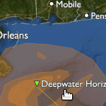
- New! Gulf oil spill. Engage your visitors with the only interactive weather maps on the web with detailed plotting of the Deepwater Horizon oil spill site and 24-hour forecast from the NOAA updated daily. You can check out this feature on our maps at Stormpulse.com.

Deepwater Horizon site & Gulf oil spill
- No upsells or advertising. To help ensure your audience stays on your site, ads and upgrade links are never displayed on a premium affiliate map.
- Super-resolution radar loops. Bright colors and fine-grained details draw your visitor’s attention to the most important features of each storm. Powered by “Level 2” data from the National Weather Service, this is the highest resolution radar available on the web.
- Tropical watches and warnings. Inform your audience of the threat to coastal areas as the storm approaches land.
As with our free maps, you can also toggle layers and add customer markers using the Stormpulse Maps JavaScript API, which we’ve designed to be familiar to anyone with Google Maps experience.
Keep the requests coming …
Weather maps for emergency operations and planners
“The most detailed, easy to navigate, fully-featured tracking site I have seen.” Evan, Dept. of Homeland Security
During the 2008 and 2009 Atlantic hurricane seasons, thousands of decision-makers from Fortune 500 executives to local marina managers used Stormpulse to visualize the impending dangers and coordinate their efforts. Since then, we’ve received hundreds of emails from these “power users” asking for more. To better serve these customers, on June 1, 2010, we launched a new series of plans focused on the needs of emergency operations and disaster response teams.
In addition to all of the features available with our base-level Stormpulse Pro plan, these plans include the ability to add additional users to your Stormpulse Pro account, severe weather alerts for up to an unlimited number of custom locations, coastline highlighting for tropical storm and hurricane watches and warnings, and a wind probabilities layer which provides an excellent visual interpretation of the National Hurricane Center’s wind speed forecasts.
What other features can you expect in 2010? How about wind probability alerts, storm surge alerts, and an enhanced version of our popular forecast models layer? With the ocean heat content rising, we’re also considering the addition of a sea-surface temperatures layer. Your feedback is appreciated!
You can read more about these plans and see an overview of key features by going to our Emergency Operations products page. You can also fill out this form if you’d like to schedule a demo for your company or team. We’d be happy to discuss your team’s specific needs.
P.S. Here’s a video on YouTube that shows Stormpulse in action at the Harris County Office of Emergency Management. This county includes the city of Houston and is responsible for an area larger than Rhode Island. Look for Stormpulse on the projectors at 0:04 and 0:10 seconds into the clip.
Add markers to weather maps with the Stormpulse API
You can now add your own location data to any Stormpulse map embedded on your site. To learn how, read our updated API documentation, or watch these video tutorials.
NOTE: This functionality is available to all API users until June 1, 2010. On June 1, 2010, certain restrictions may apply to API users embedding the map on media (mass audience) sites and API users embedding the map on corporate intranet portals.
Just another small step towards opening up our maps to the rest of the world. We look forward to adding new functions, objects, and data sets to the library.
If you would like to sign up for an API key (free), you should go to this page on our site.
Locality, beauty, and speed: major updates to Stormpulse
We’ve spent the last four months working on an update to make Stormpulse.com more local, more beautiful, and faster. And as of this morning, you can go and see for yourself.
Major highlights:
- Home page attempts to geo-locate and route you to a local weather page.
- Current conditions box shows current temperature, conditions, and winds.
- Forecast box shows high and low temperature and an hour-by-hour summary for the next three days.
- Map imagery with a resolution of 500 m/pixel–four times greater than our previous maps (so you zoom in four times closer).
- Speed boost: the map only loads the severe weather information it needs for your current view (no loading or rendering data needlessly).
- Map enhancements–clearer labeling and more beautiful terrain.
Those are the big items. Other items we get excited about:
- When viewed with an iPhone, the weather information is displayed in a friendly, readable fashion (and more mobile support coming soon).
- The ‘Share Map‘ feature now works for U.S. Severe Weather and allows you to share down to the plotpoint for a storm. For example, a close-up view of Katrina bearing down on NOLA. This will work for forecast positions during an active storm as well.
- Improved color scheme for severe weather alerts. In our first attempt at severe weather coverage, we adopted the National Weather Service’s colors entirely. Since then, we’ve seen a few big storms come and go, and a lot of winter storms come and go, and we’ve adjusted our colors to improve visibility on the critical alerts, and quiet down the less important ones.
- Simplified site navigation bar. Fewer choices with an expandable button at the end means less confusion, we believe.
- Intelligent expanding and contracting of weather info boxes in the left column. We are big believers in only showing what matters and hiding the rest. We’ve tried to make some smart decisions about what to hide and what to show by default. Tell us if you disagree!
Since so much of this is visual, I thought I’d include a few more screenshots that do this update justice.
A Winter Storm Watch in Hartford, CT:
Wintry weather in … Texas?! Yep.
As always, we looking forward to hearing what you think.
The Stormpulse Team
Nationwide severe weather on Stormpulse
This morning we updated the site to include most of the severe weather watches and warnings published by the National Weather Service (weather.gov).
This includes many, many types of hazards such as:
- Severe Thunderstorms
- Tornadoes
- Floods & flash floods
- Fire watches/warnings
- Winter storms (snow, sleet)
- Frosts/freezes
- Extreme heat
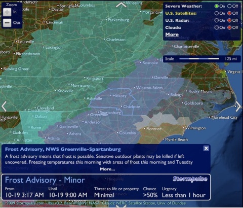
Here’s an example of some frost creeping into Charlotte, NC this morning:
We’ve adopted the same colors as the official NWS charts (though that may change), and we’ve added value (in our Stormpulse way) by making the areas clickable, by joining together neighborhoring shapes into a single area (less clutter, less confusion) when they share the same advisory/alert, and by giving you access to the complete description right inside the map.
Along with the mapping visuals, you’ll also notice we have a search box that supports searching by state, city, or zip code.

Example searches: “Memphis, TN“, “33411“, “New York, NY“, “Minnesota“, “California“, “FL“.
Play around and have fun with it, and let us know what you think. We are considering this very much an early version (‘beta’ in developer lingo), so beware of hidden bugs and potential performance issues if you are using a slower computer.
Stormpulse Advanced: the better way to track tropical weather
After many, many hours of conversation (with you) and coding (in relative isolation), we’re excited to release our new friend, Stormpulse Advanced, into the wild.
The initial feature set (shown in the screencast above):
Satellite Loops. 12-hour loops using three different kinds of imagery: rainbow, water vapor, and true color. I’m particularly fond of the true color, as we attempted to blend it as seamlessly with the Stormpulse map as possible. These loops not only animate, but can be told to auto-repeat in sync. If you love the way our big blue marble looks from space, I think you’ll love this too.
Auto-refresh. Just click this option On in the layers menu and the Stormpulse page will refresh automatically every 5 minutes. Especially handy when using Stormpulse as an continuous information display during active times of the season. This works in full-screen mode as well (counter placed in the page title bar).
Save-my-preferences. No longer do you have to turn this layer on and turn that one off each and every time you load the map. Turn a layer off and it stays off. Turn it on, and it stays on. No need to set up anything in an admin interface–our site learns your preferences as you use the map, no configuration required.
Ad-free experience. The free verion of Stormpulse is supported by advertisements, but advertisements are neither displayed nor loaded in Stormpulse Advanced.
Want to see more? Here’s another screencast I recorded this morning, showing Stormpulse Advanced’s satellite loops in action.
We hope you’re as interested in signing up as we are exhausted. In any event, we’d love to hear from you. Feel free to let us know what you think!
You should follow us on twitter here.

 Comments (2)


