Archive for the ‘hurricane season’ Category
Live weather data & video on Stormpulse during US landfalls in 2011
Filed under: features, hurricane season, mapping, release, startup, storm | Tags: hurricanes, startup, storm, stormpulse, video
 Comments (2)
 This is a guest post by Mark Sudduth, owner and operator of HurricaneTrack.com.
I am pleased to announce that HurricaneTrack.com is partnering with Stormpulse beginning today. The partnership will mean an incredible hurricane tracking experience for both of our audiences. I met with Stormpulse co-founder Matt Wensing a couple of weeks ago in Florida. We talked about some ideas that grew in to even bigger ideas and before we knew it, we had hatched a plan that will revolutionize hurricane tracking. Our plan is to combine the ultra-modern look of the Stormpulse brand with the educational, informative and live data aspects of HurricaneTrack.com. It is no secret that our Java maps are showing their age. Five or six years ago, they were cutting edge, now they are dated and were in need of a complete re-design. Instead of doing that, we have decided to add a custom Stormpulse tracking map to our homepage (as seen below). The map’s functionality will evolve over time but it will give our visitors instant access to a live hurricane tracking map from the moment an “invest” is activated by the National Hurricane Center.
Stormpulse and its related tracking maps have quickly become famous the world over. Utilized by millions of people from business, industry, government agencies and of course the avid hurricane tracker, there is no mistaking a Stormpulse tracking map. We are honored to have the privilege of providing the Stormpulse brand to our visitors. In fact, we will develop special features for our version of the tracking map not found anywhere else.
As for our contribution to Stormpulse, we will develop high resolution digital data and live video streams for Stormpulse clients. The data will be plotted on Stormpulse maps generated for specific needs of their clients- ranging from personal use to large corporate and government decision making entities. The long term goal is to blanket a region with dozens of instrumented towers to provide unprecedented live data and video streams on a level never before available. This partnership will help to facilitate that goal.
Matt had this to say regarding the new partnership:
“Mark’s proven delivery of accurate, real-time storm data and video feeds during landfalls makes the HurricaneTrack team an excellent extension to the Stormpulse platform. Working together is an obvious and natural fit which will allow us to demonstrate what can be done when you bring together the right expertise.”
Today’s announcement is only the beginning to what we both see as an enormous opportunity to serve both of our user bases with the best tools available. The entire HurricaneTrack.com team looks forward to pushing the limits of what we can do with the power of Stormpulse on our side.
Enterprise plans for any number of users and alert locations
Since launching Stormpulse Pro in the summer of 2009, we’ve continued to evolve the product to make it the best storm-tracking subscription on the web.
This morning we’re taking Stormpulse’s instant weather intelligence one step farther by giving you the power to choose the exact number of users and alert locations you need, rather than forcing you to choose between tiers of service that were either too little or too big for your needs.
We encourage you to please take a moment and visit our new configurable plans page. There are many places to get weather information, but Stormpulse is now offering the most consolidated, transparent and customizable way to get your team going in minutes.
Need a quote for your budget? After typing in the number of users and alert locations you want, just click the ‘Quote’ link next to the ‘Select’ button for a personalized PDF describing your custom plan and rates.
Need to explain Stormpulse to your co-workers? Download the new Stormpulse brochure (pdf), which includes the story of how a Fortune 500 company saved time and avoided a costly mistake by watching Stormpulse.
What’s coming in 2011? Over the next few weeks we will continue to unveil our plans for 2011, including mobile apps, real-time weather data and video during U.S. landfalls, text alerts for your mobile phone, and chance alerts, so you can get an update when there’s a specific chance of severe weather at any of your alert locations.
Here’s to the close of the 2010 Atlantic hurricane season (despite the low-potential disturbance currently churning in the south Caribbean) and a very Merry Christmas.
Weather maps for emergency operations and planners
Filed under: features, hurricane season, mapping, release | Tags: emergency ops, hurricane season, tracking, weather
Comments (2) 
“The most detailed, easy to navigate, fully-featured tracking site I have seen.” Evan, Dept. of Homeland Security
During the 2008 and 2009 Atlantic hurricane seasons, thousands of decision-makers from Fortune 500 executives to local marina managers used Stormpulse to visualize the impending dangers and coordinate their efforts. Since then, we’ve received hundreds of emails from these “power users” asking for more. To better serve these customers, on June 1, 2010, we launched a new series of plans focused on the needs of emergency operations and disaster response teams.
In addition to all of the features available with our base-level Stormpulse Pro plan, these plans include the ability to add additional users to your Stormpulse Pro account, severe weather alerts for up to an unlimited number of custom locations, coastline highlighting for tropical storm and hurricane watches and warnings, and a wind probabilities layer which provides an excellent visual interpretation of the National Hurricane Center’s wind speed forecasts.
What other features can you expect in 2010? How about wind probability alerts, storm surge alerts, and an enhanced version of our popular forecast models layer? With the ocean heat content rising, we’re also considering the addition of a sea-surface temperatures layer. Your feedback is appreciated!
You can read more about these plans and see an overview of key features by going to our Emergency Operations products page. You can also fill out this form if you’d like to schedule a demo for your company or team. We’d be happy to discuss your team’s specific needs.
P.S. Here’s a video on YouTube that shows Stormpulse in action at the Harris County Office of Emergency Management. This county includes the city of Houston and is responsible for an area larger than Rhode Island. Look for Stormpulse on the projectors at 0:04 and 0:10 seconds into the clip.
Stormpulse Advanced: the better way to track tropical weather
After many, many hours of conversation (with you) and coding (in relative isolation), we’re excited to release our new friend, Stormpulse Advanced, into the wild.
The initial feature set (shown in the screencast above):
Satellite Loops. 12-hour loops using three different kinds of imagery: rainbow, water vapor, and true color. I’m particularly fond of the true color, as we attempted to blend it as seamlessly with the Stormpulse map as possible. These loops not only animate, but can be told to auto-repeat in sync. If you love the way our big blue marble looks from space, I think you’ll love this too.
Auto-refresh. Just click this option On in the layers menu and the Stormpulse page will refresh automatically every 5 minutes. Especially handy when using Stormpulse as an continuous information display during active times of the season. This works in full-screen mode as well (counter placed in the page title bar).
Save-my-preferences. No longer do you have to turn this layer on and turn that one off each and every time you load the map. Turn a layer off and it stays off. Turn it on, and it stays on. No need to set up anything in an admin interface–our site learns your preferences as you use the map, no configuration required.
Ad-free experience. The free verion of Stormpulse is supported by advertisements, but advertisements are neither displayed nor loaded in Stormpulse Advanced.
Want to see more? Here’s another screencast I recorded this morning, showing Stormpulse Advanced’s satellite loops in action.
We hope you’re as interested in signing up as we are exhausted. In any event, we’d love to hear from you. Feel free to let us know what you think!
You should follow us on twitter here.
Hola, aloha: Stormpulse expands to the Pacific basin
Filed under: features, hurricane season, release, welcome | Tags: stormpulse pacific hurricanes
Comments (6) Please note: the full-screen view and the Stormpulse API do not yet work for the Pacific basin. We are working to resolve this in the near future. Update: Our embeddable maps now work for the Pacific basin. Our API instructions have been updated to show you how.
One of the most popular requests we received last year was for us to broaden our coverage from the Atlantic to the Pacific basin.
So, after rolling up our sleeves in the off-season, we quietly launched our coverage of the Eastern Pacific basin on May 15th (coinciding with the 1st day of the Eastern Pacific season).

We’ve added storm information back to 1949, buoy reports, wind probabilities, and satellite imagery. Something we don’t have yet: forecast/spaghetti models. Our source for the Atlantic spaghetti models (the South Florida Water Management District) does not provide this data, so we’re looking for a source. If you know where we can get fairly clean text data for model tracks in the Eastern Pacific, let us know!
Additionally, you can get automatic updates on changes in Eastern Pacific Basin storms via our Stormpulse Pacific twitter account: @stormpulsepac.

Hope all of your out west and out in the big blue sea find this helpful. Send us your feedback when you get a chance (and let us know where can find spaghetti model info if you happen to know!).
Invest 94 to become Tropical Storm Gustav? The early morning report from buoy 42059.
According to a buoy stationed just east of the high-potential tropical disturbance also known as Invest 94L, steady winds of 25 mph and gusts of 31 mph were recorded out of the SSE at 5:50am this morning. With an observed water temperature of 84.56 degrees F (before sunrise!), there should be plenty of warm water fuel should the storm develop any further.
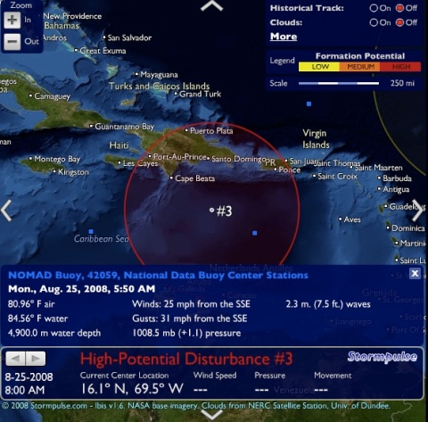
An Air Force Hurricane Hunter aircraft is scheduled to explore the storm later today. Current models (something that should be coming to a Stormpulse map near you very soon), indicate a west-northwest progression, with the GFDL turning the storm north over western Cuba.
In case you’re wondering, here’s what that lonely and very useful buoy looks like, bobbing out in the middle of the Caribbean Sea (with 4,900 m of water below). (You can click the image for complete details).

PalmBeachPost.com embeds our hurricane-tracking map
Filed under: hurricane season, release, startup | Tags: announcement
Comments (7) The Palm Beach Post has begun embedding Stormpulse’s tracking map on their own hurricane site, Storm2008.
![]()
We are very happy to be able to take a step forward in getting our tracking map in front of a larger audience, and the Post is happy to receive a major upgrade to their storm mapping displays. This enhancement also coincides with what is turning out to be an active July, with Tropical Depression Three forming as I write this.
The Palm Beach Post is the first, but hopefully not the last, place where our embeddable map should surface. Anyone interested in embedding the map on their own site, using a simple JavaScript tag, is welcome to reach out to us via this blog or our email address (stormpulse at gmail dot com). We look forward to hearing from you.
Hurricane Bertha highlights challenge in forecasting
In the National Hurricane Center’s Discussion #19 on now-Hurricane Bertha the Forecaster Rhome states:
“BERTHA’S INTENSIFICATION TO MAJOR HURRICANE TODAY HIGHLIGHTS THE DIFFICULTIES OF FORECASTING RAPID INTENSITY CHANGES.”
I wonder if this difficulty will ever go away through sheer computing power, or if something a bit more human is required. Could human-consensus forecasting address this weakness? Still unproven, but it seems worth a shot.
Human-consensus hurricane forecasting
UPDATE (8/28/07): We’ve launched the release. You can now register to become a forecaster at Stormpulse.com. Or read more about the release.
“Through computer advances, model forecasts very likely will continue to improve, assuming we remember one fundamental problem with tropical cyclone forecasting: maximizing observations.“
“Numerical prediction of tropical cyclone tracks has improved tremendously since the early models of the 1950s and 1960s. Ironically, today’s reliance on model guidance has possibly led to the decline in skill of subjective tropical cyclone forecasts. It is hard to imagine that landfall forecasts in the 1970s were about as good as they are today and watch/warning areas were smaller. Back then forecasters relied very much on subjective forecast techniques. Today they rely heavily on model forecasts. Revitalizing and improving subjective analysis and forecast skills without inhibiting numerical model advances could provide significant improvements in track forecasts.“
— Dr Steve Lyons, “Hurricane Forecasting Considerations“
We’re going to take on the problem Dr Lyons mentions above by applying the concept of the wisdom of crowds to hurricane forecasting.
How?
This week we’re going to be adding some significant enhancements to the Stormpulse website. One of these is the ability to create an account (free and painless, we promise!), which you’ll need to do if you want to participate in our forecasting system. Then, the next time there’s an active storm (post-Dean), you’re going to tell us where you think the storm is going to go by filling out a slick little form on the Stormpulse home page (just below the map) that asks you where the storm will be in 12, 24, 36, 48, 72, and 120 hours, as well as what the intensity (maximum wind speed) of the storm will be at those points in time. Then we’re going to take everyone’s forecasts and aggregate them in order to see if we can accurately forecast the movement and strengthening (or weakening) of tropical cyclones.
Wait a minute! Aren’t there all kinds of forecasting models out there already?
Yes. But this will be, as far as we know, the world’s first human-consensus hurricane-forecasting model.
Do you guys think you are some kind of experts?
No. In fact, that’s the point of the system—to de-emphasize the individual experts and discover the collective expert (and more importantly, the collective expert’s forecasts).
Why might this work?
The idea to do this hit us on the head in July of 2006. Since then, we’ve had it mostly under wraps, sharing the idea with close acquaintances and friends while gathering insight wherever we could find it. And all of our research pushes us toward the conclusion that this just might work.
For example, in June of this year (2007), we attended the Governor’s Hurricane Conference in Ft. Lauderdale, Florida. While there, we attended a few classes on tropical meteorology. In those classes, our suspicions about the very small world of professional hurricane forecasting were affirmed, insofar as it has several characteristics that make it ripe for disruption by a more democratic process:
- It is a world currently dominated by a few experts. Dr Gray of Colorado State University, Dr Steve Lyons of The Weather Channel, the Hurricane Research Team at NASA, the forecasters at the National Hurricane Center . . . all of these folks are considered experts, and rightly so. They are. But if the research behind the wisdom of crowds theory is correct, it would stand to reason that none of these experts in isolation will consistently perform better than a diverse, independent group. [1]
- It contains subjectivity, for better or for worse. For better, that subjectivity represents valuable intuition and insight—”I can feel it in my bones!” For worse, that subjectivity represents the unavoidable flaws of human judgment.
- It contains traces of bureaucracy. Don’t get me wrong—this is not a criticism of the National Hurricane Center or anyone other group of professionals whose great challenge it is to produce accurate, timely, and responsible forecasts. But, nevertheless, all groups of professionals wherein there is some order, structure, and authority will contain some amount of bureaucracy that could hinder its performance. Is that going too far? I don’t think so. If you’re misunderstanding me, let me know and I’ll try to restate this. All we’re saying is, the existing system necessarily contains rules and politics that make the system imperfect. I am pointing out that imperfection to underscore the opportunity to improve.
- Satellite data and images are underutilized in existing computer models. Current computer models have a limited ability to digest data gathered via satellite. This is unfortunate since satellite images are the best views we have of what’s going on inside a storm. Having tens, hundreds, or even thousands of human interpreters of satellite data provide their input into a human-consensus model should boost the accuracy of a resulting, synthesized forecast.
- Existing models are weak in predicting storm intensity and size. While track guidance has improved greatly due to advances in computing power, intensity predictions have not seem the same increase in accuracy. Trying something completely different—calling on an army of human forecasters instead of depending greatly on computers, could prove to be a breakthrough in this area. Even if what emerges is a complete failure in providing track guidance, what a human-consensus model provides in forecasting intensity, storm size, and storm surge could prove beneficial for years to come over computer-only calculations.
- Computer-consensus models have performed well. In a report written by the NHC in 2006, it was shown that the consensus models GUNA and CONU provide the best track guidance. At the conference, a forecaster from the National Hurricane Center told the audience that “for some reason it would seem that the [statistical/dynamic] models have offsetting biases in them that cancel each other out when you average them together.” Our thoughts exactly, which brings us to the next and most subtle point:
- You are a forecasting model. If the above (#6) is true, why stop at making a consensus out of only the computer models? Why not attempt to aggregate and synthesize all of the available models—computer and human, to produce one unified forecast?
Won’t all of the novices or intentional misanthropes spoil the system?
No. We are going to keep track of user’s performance and weigh the credibility of their forecasts accordingly. So, if Bob is consistently off by 500 miles at 12 hours out, we’re going to take his forecasts with a grain of salt in our final equation. On the other hand, if someone, no matter what his position in the world of weather, continually proves to be an accurate forecaster, we are going to weigh his forecast more heavily.
What about privacy?
If you choose to participate, whether or not your name shows up anywhere on our site or is ever shared outside of Stormpulse, Inc. will be up to you. For those that don’t mind their identity being attached to their performance, we are planning to publish rankings that show where you stand against the rest of the participants.
Where can this go?
Near the end of 2008 there is going to be a re-opening of the Joint Hurricane Testbed, a government program wherein the National Hurricane Center carefully considers suggestions as to how they can improve their forecasting process. If this works in any measure, that’s one possible outcome.
Are you serious? / That won’t work. / Wow, that’s cool!
Yes. / OK. / Thanks, we’ll see.
[1] It’s noteworthy that the National Hurricane Center already embraces this truth insofar as forecasters work on rotation. Also, there is a rule that a forecast may not drastically differ from its predecessor. While on the one hand this may suppress a moment of brilliance (and that’s where there’s an opportunity to improve), this avoids public outcry and fear over flip-floppy forecasts and is in effect a mechanism to bend toward a consensus.
Buzz brewing
I can’t explain why, but for some reason our site has been seeing a bump in traffic lately. My only guess is that hurricane season fever is upon us all down here; most people are coming in directly, without any kind of referring link. I’m guessing the conversation goes something like this:
Bob: ‘Hey Fred, when do you think we’ll get a hurricane this year?’
Fred: ‘Beats me, but check out this website I found the other day . . . ‘
In any event, it’s cool to see new visitors. Hope you’re finding your visit worth your while. Send us your feedback!
New features coming soon. We’re getting pretty excited in the labs. One will be the ability to create an account at Stormpulse.com, and the rest will revolve around doing some pretty neat stuff that you can’t do on any other weather websites. No, really. :-)
